According to China Weather Network, today (March 12), cold air continues to move eastward and southward, and many places in the central and eastern regions will start cooling mode. Tomorrow to weekend, a new cold air will be seamlessly connected. The temperature in various places will drop to the recent lows around the 16th. There are great differences in cooling and heating in many places from Northeast to Jiangnan. The public needs to adjust their dressing in time according to temperature changes to reduce the risk of colds. At the same time, the south is facing a significant rainfall process, with heavy rainstorms in many places in South China accompanied by strong convection.
The central and eastern regions started cooling mode and dropped to the low temperature around the 16th
Yesterday, cold air was powerful, and the northwest region, Inner Mongolia and other places were the core areas for cooling, with the local temperature drop exceeding 8℃.
Today, this cold air continues to move eastward to affect our country, and various parts of the central and eastern regions will gradually usher in cooling. Three days from tomorrow, there will be a new wave of cold air moving eastward and southward, with a stronger intensity than the current one. Under the continuous influence of two cold air, the temperature in most parts of my country will fluctuate and decline from this to the weekend, and the cumulative drop in the highest temperature in many places can reach more than 10℃, from a sharply warmer to a significantly colder one.
Around the 16th, the temperature in various places will drop to the low point, the maximum temperature of 15℃ will retreat to southern Jiangnan, and the maximum temperature in many places from southern North China to the Yangtze River will drop to around 10℃. Among big cities, the highest temperature in Changchun yesterday was 14℃, which will fall to 5℃ today. The highest temperature in Nanjing yesterday was above 20℃, and the highest temperature on the 15th will be only 9℃. There are great differences in temperature and temperature in the above areas. The public should pay attention to temperature changes, add clothes in time, and beware of colds.
The impact range of sandstorm weather expands eastward. Heavy rainfall and strong convection are present in many places in South China. Dust or sandstorm appears in central and southern Xinjiang, central and eastern Gansu, central Inner Mongolia, Ningxia, central and northern Shaanxi, Shanxi, western Hebei, western Beijing, southern Tianjin and other places. At the same time, the rain and snow weather in the north has increased, with light to moderate snow in some areas such as northern Xinjiang, southeastern Qinghai, and northeastern Inner Mongolia, and heavy snow in some areas.
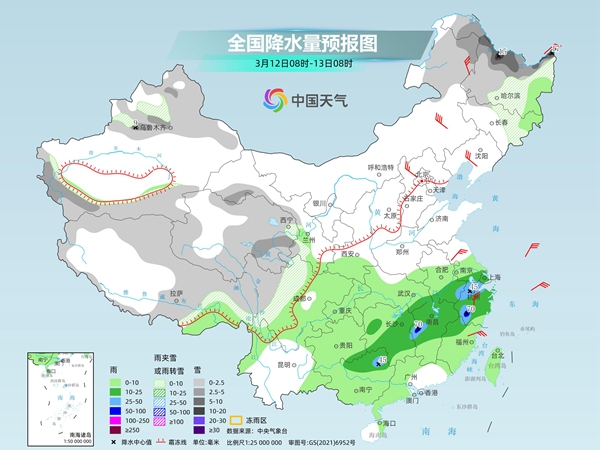
From today to weekend, there will be obvious rainfall in the south, and many places in the south of the Yangtze River and South China may be hit by heavy rain. The Central Meteorological Observatory predicts that today, there will be light to moderate snow or sleet in some areas of northeastern Inner Mongolia, most of Heilongjiang, northern Jilin, northern Xinjiang, eastern Tibet, central and eastern Qinghai, western Gansu, western Sichuan Plateau, etc., among which there will be heavy snow in some areas of northern Heilongjiang, the Yili River Valley, Xinjiang, and some areas of blizzard in northern Heilongjiang. There will be light to moderate rain in some areas such as Jianghuai, Jianghan, Jiangnan, eastern Southwest, central and western South China, Taiwan Island, etc., among which there will be heavy rain in some areas such as Jiangxi, western Zhejiang, and northeast Guangxi, and local heavy rain.
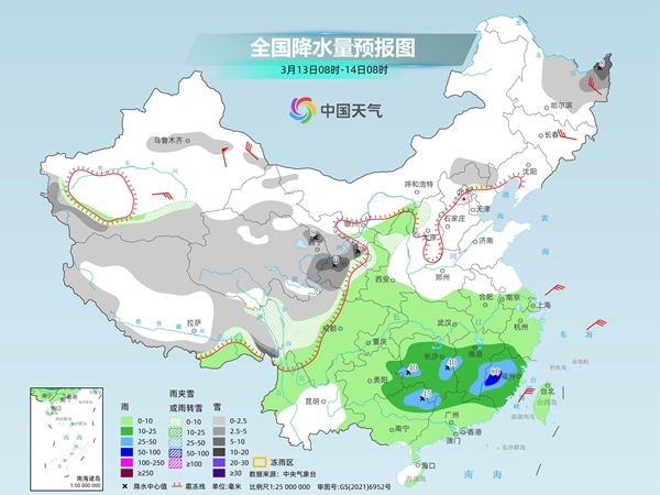
Tomorrow, there will be light to moderate snow or sleet in some areas of central and eastern Heilongjiang, Xinjiang's Tianshan area, northern and eastern Tibet, Qinghai, central and southern Gansu, Ningxia, western Sichuan Plateau, and other places. Among them, heavy snow will be found in some areas of northeastern Heilongjiang, eastern Qinghai, central and southern Gansu, and southern Ningxia. There will be light to moderate rain in some areas of the eastern part of the northwest region, the eastern part of the southwest region, the Jianghuai, Jianghan, Jiangnan, South China, Taiwan Island, etc., among which there will be heavy rain in some areas of northern and western Fujian, western and southeastern Jiangxi, central Hunan, northeastern Guangxi, and heavy rain in some areas of western Fujian.
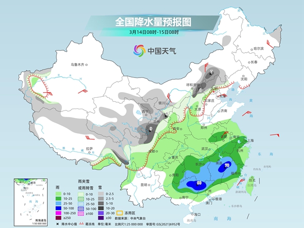
The day after tomorrow, there will be light to moderate snow or sleet in western and southern Inner Mongolia, central and southern Gansu, southern Qinghai, eastern Tibet, western Sichuan Plateau, Ningxia, northern Shaanxi, central and northern Shanxi, northern Hebei, and other areas. Among them, moderate to heavy snow will be found in some areas such as southern Inner Mongolia, southwestern Gansu, southern Ningxia, northern Shanxi, and northern Sichuan Plateau. There will be light to moderate rain in some areas of the southeastern northwest region, eastern southwest region, southern Huanghuai, Jianghuai, Jianghan, Jiangnan, Jiangnan, central and northern South China, among which there will be heavy rain or heavy rain in some areas of northeastern Guangxi, northeastern Guangdong, southern Hunan, central and southern Jiangxi, and northwest Fujian.
From this year to the weekend, there will be large-scale rainfall in the south. The rain in Jiangnan and some areas of South China may appear, and there may be heavy rain. The above areas are accompanied by strong convective weather such as short-term heavy rainfall, thunderstorms and strong winds. In addition, there is still snowfall in many places in Heilongjiang and eastern Inner Mongolia today. We need to be wary of the adverse effects of snow accumulation and road icing on traffic.