China Weather Network News Today (April 12), strong winds entered the core impact period. There were nearly 500 national meteorological observation stations across the country that strong winds broke records. The winds in North China, Huanghuai and other places were particularly strong. The extreme wind speed in local areas such as Henan, Beijing, and Tianjin once reached or exceeded level 13. The strong winds are not only strong, but also expand very quickly. Currently, many places in Jiangnan are also affected by strong winds. Why is the strong wind so strong? Why is the expansion speed so fast? How long will it last in the future? China Weather Network interprets it for you one by one.
1. How strong is the strong wind?
Monitoring data shows that from 15:00 yesterday to 15:00 today, a total of 493 national observation stations across the country broke the record of extreme winds in the same period in April. Among them, the winds in Hebei and Henan were particularly strong, with strong winds at 95 stations and 61 stations in Henan respectively breaking the record. The wind speed in the Beijing-Tianjin area was also very strong. Among them, the wind speed of Panshan Station in Jizhou District, Tianjin once reached level 14, breaking through the extreme value of the same period in history since 1951; the wind speed in Beijing gradually increased this morning, and the extreme wind speed of Mentougou Gaoshan Rose Garden once reached 45.8 meters/second (level 14), Fangshan Industrial Park in Qianshan District 39.0 meters/second (level 13), and Yanqing District Racing Station 5 37.5 meters/second (level 13).
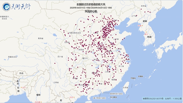
As of 15:00, 493 national observatory stations across the country broke the record for the same period in April.
The power of strong winds cannot be underestimated. Affected by strong winds, as of 15:00, more than 800 big trees in Beijing were blown down and 30 cars were smashed; roofs and floor-to-ceiling windows of buildings were blown away in Shanxi, Henan and other places. According to the statistics of the Feichangzhun Civil Aviation Profile, as of 12:00 today, more than 3,200 flights have been cancelled on domestic routes, which is the highest value for flight cancellations this year.
2. Why is the strong wind so strong?
Why is the wind in this process so strong? Xin Xin, chief analyst of China Weather Network, said that high pressure gradients and high altitude momentum downstream are the main reasons for strong winds. During this process, the high-altitude cold and high pressure were strong, and temperate cyclones were formed on the ground in Inner Mongolia, resulting in an increase in the pressure gradient. In winter and spring, when strong cold air hits a strong warm and humid airflow, it can twist and rotate counterclockwisely when a word is disagreeable, and a temperate cyclone is born. "It is like a constantly rotating weather gyro. If other weathers are used to cooperate, it is like an invisible whip repeatedly, making the gyro rotate faster and faster, and the power will increase sharply in a short period of time, resulting in strong winds. The degree of wind is no less than that of a typhoon when it is the strongest." Xinxin explained.
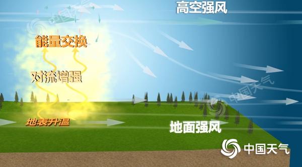
In addition, the downward transmission of high altitude momentum will also make the wind stronger. In spring, high altitudes are often still in the circulation situation in winter, with dense contours and high wind speeds. When the weather is clear and the surface is quickly heated, the air near the surface expands and rises due to heat, forming turbulent exchanges in the vertical direction, transmitting high winds from high altitudes to the ground, resulting in strong ground winds.
3. Where does strong winds above level 13 in Beijing appear?
Monitoring shows that from 17:00 on the 11th to 15:00 on the 12th, nearly 60% of the observation stations in Beijing had extremely strong winds of level 9 or above, and strong winds above level 10 appeared in Haidian, Chaoyang, Fengtai, Shijingshan, Tongzhou, Fangshan, Changping, Huairou, Pinggu, Mentougou, Yanqing, Miyun and Shunyi. The largest gust of wind speed in the city was 45.8 meters/second (level 14).
In April of each year, gusts of level 10 to 11 occur in North China and Huanghuai, and strong winds exceeding level 12 are rare. During this process, strong winds above level 13 in Beijing appeared in Mentougou and Fangshan. These places are at a high altitude and are more likely to experience extreme strong winds due to the "narrow tube effect". The occurrence of narrow tube effect is mainly related to the terrain. When strong winds flow from open areas into narrow terrain (canyon), the air quality cannot accumulate in large quantities, so it accelerates through the canyon and the wind speed increases. This situation is also prone to occur in areas with dense high-rise buildings in the middle and high-rise areas. When a strong wind of level 6 or seven is blowing, the narrow tube effect can make the instantaneous wind force pass through the high-rise buildings reach level 12, causing billboards, glass and even walls to fall.

A narrow tube effect is prone to occur between high-rise buildings.
4. Why does the strong wind quickly move south overnight?
The strong winds brought by the cold air this time are not only very strong, but also expanding very fast. They quickly moved south overnight. Today, the strong winds in front of the Nanling area had arrived at the front of the Nanling area around 15 o'clock. Xinxin introduced that the rapid expansion of the influence of strong winds is related to the speed of cold air movement. During this cold air process, the high-altitude trough in the north is deep and the high-altitude guided airflow is very strong, causing the ground cold and high pressure to quickly advance southward, so the strong winds quickly swept across the country.
Today, Hubei, Shanghai, Zhejiang and other places were also affected by the superposition of cold air southward, and strong winds occurred, with local extreme winds exceeding level 10. Xinxin introduced that due to strong winds, sandstorms have also occurred in many places in the south. The PM10 concentration in many places such as Yunnan, Guizhou, Guangxi and other places has increased, and the air quality index in many places in Jiangnan has exploded. At 12:00 in Nanchang, the PM10 concentration reached 1,240 micrograms/cubic meter, which is very rare.
5. How long will the strong wind blow?
It is expected that as the influence of cold air gradually ends tomorrow, strong winds in the south will gradually weaken. However, strong winds in the north will continue. As the ground cyclones and high-altitude cold vortex move eastward, northerly airflow continues to move southward in the back of the cold vortex. Local gusts in central Inner Mongolia, northern Hebei, western Beijing and northern mountainous areas can reach level 10 to 11.

China Weather Network reminds the public in relevant regions to continue to take precautions, close doors and windows at home, fix temporary buildings, minimize going out, avoid staying under large outdoor billboards and big trees, and cars also park in relatively empty venues or underground garages to prevent objects or trees from being hit by high altitudes. (Planning/Jiang Yi Data Support/Sun Qianqian Xinxin Photo/Sun Guannan Luo Jiaxue Review/Liu Wenjing Yu Xiaofen)