CCTV News: According to China Weather Network, from tomorrow (April 11), strong cold air will affect most areas in the central and eastern regions, with the temperature dropping by 6℃ to 10℃, and the drop in some areas can reach 12℃ to 16℃. While cooling down, strong winds are significant in North China and other places, with gusts of level 8 to 10, and local conditions may reach level 11 or above. In addition, there will be moderate to heavy snow or sleet in some areas of central and eastern Inner Mongolia and northeastern regions, local blizzards or heavy snow, and the rainfall in the south will increase, which will usher in the largest range of strong convective weather this year.
The temperature in the central and eastern regions has dropped significantly from tomorrow. The gusts of North China and other places can reach level 8 or above.
Since this week, the central and eastern regions have entered a warming expressway. Yesterday, the highest temperature reached 20℃ in northern North China, and some places in eastern Inner Mongolia, Jilin and Heilongjiang also reached 20℃. The maximum temperature in many places from the Sichuan Basin to the middle and lower reaches of the Yangtze River is around 30℃, which is as hot as early summer.
Today, warm and heat in the central and eastern regions continue, with the maximum temperature of 20℃ line reaching the northern part of Heilongjiang, the maximum temperature in central and southern North China and most areas south of the south will exceed 25℃, and in some areas it exceeds 30℃. The highest temperatures in places like Xi'an, Hefei, Wuhan, Nanjing, Shanghai, Nanchang, Chengdu will remain at around 30℃ today.
Tomorrow and the day after tomorrow, strong cold air will affect central and eastern my country, with temperatures falling by 6℃ to 10℃ in most areas, and local cooling amplitudes in the eastern northwest region, central and eastern Inner Mongolia, western and northern North China, and southern Northeast China, etc. can reach 12℃ to 16℃. Among them, the eastern part of the northwest region to western North China will be the core area for cooling tomorrow, and most of the central and eastern regions will experience significant cooling the day after tomorrow.
The temperature lows in various places generally occur around the 12th, and the maximum temperature 20°C line will retreat to the south of the Huaihe River, and the temperature level will temporarily change from a sharply high in the previous period to a low.
While cold air brings cooling, there will be cyclones tomorrow and the day after tomorrow. The pressure gradient between cyclones and cold high pressure is large, and the high altitude momentum is transmitted. The strong winds in North China and other places are significant, with gusts of level 8 to 10, and locally, may reach level 11 or above. It is recommended that the public minimize going out and pay attention to wind protection.
There will be strong rain and snow in the central and eastern Inner Mongolia northeastern region. The south welcomes the largest strong convective weather this year.
With the arrival of strong cold air, from the beginning of the next three days, there will be moderate to heavy snow or sleet in some areas such as central and eastern Inner Mongolia, northwestern Heilongjiang, eastern Jilin, and northeastern Liaoning, and local blizzards or heavy snow.
In the south, cold air and low-altitude rapids in the southwest will develop rapidly tomorrow and the day after tomorrow. At the same time, due to the unstable and sufficient energy of water vapor and atmosphere, rainfall will also be accompanied by intense and strong convective weather, and the south will usher in the largest range of strong convective weather this year.
Specifically, today, there will be light snow or sleet in some areas along the Tianshan Mountains and the southern Xinjiang Basin, southern Qinghai, Gansu Hexi, northeastern Inner Mongolia, eastern and southern Tibet, and northern western Sichuan Plateau. There will be light to moderate rain in some areas of southern Shaanxi, northeastern Sichuan, Chongqing, central and southern Zhejiang, southern Hunan, central and southern Jiangxi, Fujian and other places, among which there will be heavy rain in some areas in southwest Chongqing.
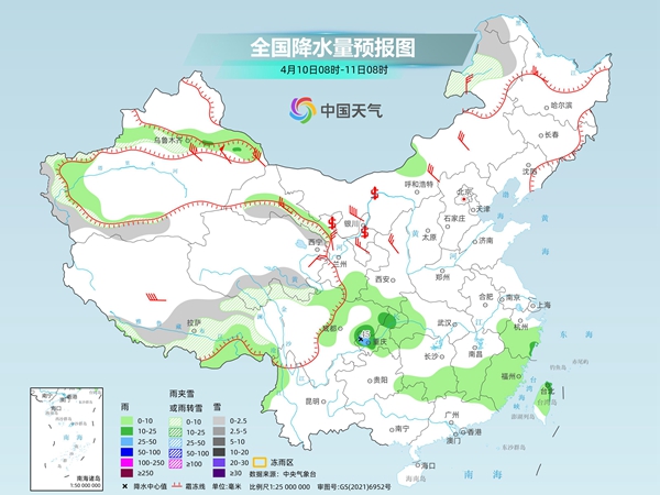
Tomorrow, some areas of southern Xinjiang, eastern and southern Qinghai, central and eastern Inner Mongolia, northwestern Heilongjiang, northern Hebei, eastern and southern Tibet, among which there will be heavy to moderate snow or sleet in some areas of eastern Inner Mongolia, and heavy blizzards in some areas of northeastern Inner Mongolia. There will be moderate to heavy rain in some areas such as most of the Jianghuai River, most of the Jianghan River, most of the Jiangnan River, and northern South China. Among them, there will be heavy rain to heavy rain in some areas such as eastern Hubei, southwestern Anhui, southern Hunan, central and northern Jiangxi, southwestern Zhejiang, northwestern Fujian, and northeast Guangxi.
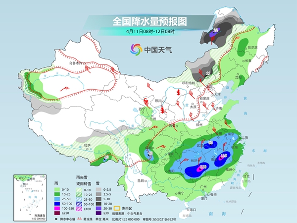
The day after tomorrow, there will be light to moderate snow or sleet in some areas of eastern Inner Mongolia, northwestern Heilongjiang, central and eastern Jilin, eastern Liaoning, eastern Liaoning, northern Liaoning, southern Liaoning, southern Liaoning, southern Liaoning, southern Liaoning, southern Liaoning, southern Liaoning, southern Liaoning, southern Liaoning, northern Hebei, southern Qinghai, eastern Tibet, and northern Sichuan Plateau. Among them, there will be heavy to moderate snow or sleet in some areas of eastern Inner Mongolia, eastern Jilin, northeastern Liaoning, northwestern Hebei, southern Qinghai, and other places. Moderate to heavy rain will occur in some areas such as western Heilongjiang, western Jilin, northern Liaoning, most of Guangdong, most of Fujian, and southern Zhejiang.
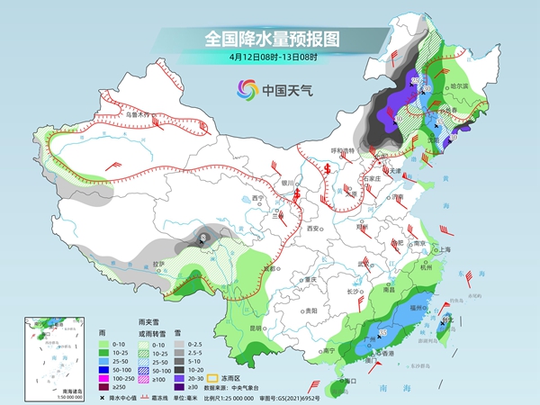
China Weather Network reminds that there will be obvious rain and snow in the eastern and northeastern regions of Inner Mongolia tomorrow and the day after tomorrow. The public should pay attention to local early warning and forecast information and pay attention to traffic safety when traveling. At the same time, rainfall in the south is increasing, and some areas are accompanied by strong convective weather. The public should try to avoid going out during periods of strong wind or active convective, and pay attention to safety.