CCTV News: According to the Central Meteorological Observatory, during the day today, light to moderate snow or sleet occurred in Xinjiang, Henan and other places; strong winds occurred in the Qinghai-Tibet Plateau and western Sichuan; and the cooling of the Huanghuai, Jianghuai, Jianghan and northern Jiangnan areas was significantly reduced. It is expected that there will be heavy snowfall in Gansu, Shaanxi, Henan, Hubei and other places from February 1 to 2, and the risk of blizzard disasters is high. We will pay attention to the impact on Spring Festival transportation, urban operation, facility agriculture, energy supply, etc.; in recent days, the winds in Tibet, Qinghai and western Sichuan Plateau in my country are relatively strong, and we will pay attention to the impact of strong winds; the Qiongzhou Strait and the coastal areas of South China are paying attention to the impact of heavy fog and low visibility weather on shipping. Cold air will affect the central and eastern regions from February 2 to 3.
1. Real weather
1. Light to moderate snow occurred in some areas of Xinjiang, Henan and other places.
During the day today, light to moderate snow or sleet occurred in some areas of northern Xinjiang, southeastern Qinghai, northern western Sichuan Plateau, central and southern Henan, northwestern Hubei, southeastern Shandong and southern Heilongjiang; moderate rain occurred in some areas of northeastern Hunan, northwestern Jiangxi, northeast Guangxi and other places, and heavy rain occurred in some areas. Strong winds of 7 to 9 will occur in central and western Tibet, southern Qinghai, western Sichuan Plateau, etc., and in some areas, levels 10 to 12. At 14:00 this day, the temperature in some areas of central and southern Henan, most of Hubei, Anhui, eastern Shandong, western Jiangsu, eastern Hunan, central and northern Jiangxi, and central and northern Zhejiang fell by 6 to 8°C, and the local cooling dropped by 10 to 14°C.
2. Key weather forecast
1. There will be a large range of rain and snow weather in the southern region
From the night of January 31 to February 2, there will be a large range of rain and snow weather in the southern region. There will be light to moderate snow or sleet in Gansu, southern Shaanxi, central and southern Henan, northwestern Hubei, etc., and heavy snow will be found in some areas such as the Qinling Mountains in Shaanxi, northwestern Hubei, southwestern Henan, and central Gansu. The snow accumulation depth in the above areas was 1 to 3 cm, and the local area was more than 5 cm. Light to moderate rains are seen in most parts of the south.
From February 2 to 3, cold air affected the central and eastern regions, with temperatures dropping by 4~6℃ in most areas, and some areas in the southeastern north China, northern Northeast China, eastern Jiangnan, and southern China fell by 6~8℃. The northern regions were accompanied by winds of 4~5 and gusts of 7~8. There will be strong winds in the eastern and southern waters with gusts of level 6 to 8 and gusts of level 9. In addition, in the next three days, there will be strong winds in most parts of Tibet, southern Qinghai, western Sichuan Plateau, northern Yunnan, etc., with winds of level 5 to 7 and gusts of level 8 to 10, and gusts of some areas of Tibet can reach level 11 or above.
2. There will be heavy fog in the Qiongzhou Strait and other waters
It is expected that from the night of January 31 to the morning of February 1, there will be heavy fog with visibility less than 1 kilometer in the Qiongzhou Strait, the western coastal waters of Guangxi, and the coastal waters of Fujian. Among them, there will be intermittent thick fog with visibility less than 500 meters in some periods of the Qiongzhou Strait. In addition, there is heavy fog in the eastern part of the Sichuan Basin, central and western Chongqing, southern Zhejiang, central and northern Fujian coastal areas, and southern Leizhou Peninsula, and there is thick fog with visibility of less than 500 meters in some areas. The Central Meteorological Observatory continued to issue a yellow warning for heavy fog at 18:00 on January 31.
3. Specific forecast for the next three days
20:00 on January 31 to 20:00 on February 1, there will be light to moderate snow or sleet in some areas such as northern Xinjiang, northeastern Inner Mongolia, northern Heilongjiang, southeastern Tibet, southeastern Qinghai, western and southeastern Gansu, southern Shaanxi, central and southern Henan, western Anhui, northwestern Hubei, and northern western Sichuan Plateau, and there will be light to moderate snow or sleet in some areas, with heavy to blizzards (10-12 mm). Light to moderate rain (10-20 mm) will occur in some areas such as most of the Jianghuai River, southern Jianghan, southern Jiangnan, eastern Southwest China, northwestern South China, and Taiwan Island. There will be 4 to 6 winds in some areas of central Inner Mongolia, Liaodong Peninsula, Shandong Peninsula, central Anhui, most of Zhejiang, southern Qinghai, and most of Tibet. Among them, there will be 6 to 7 winds in some areas of central and western Tibet (see Figure 1).
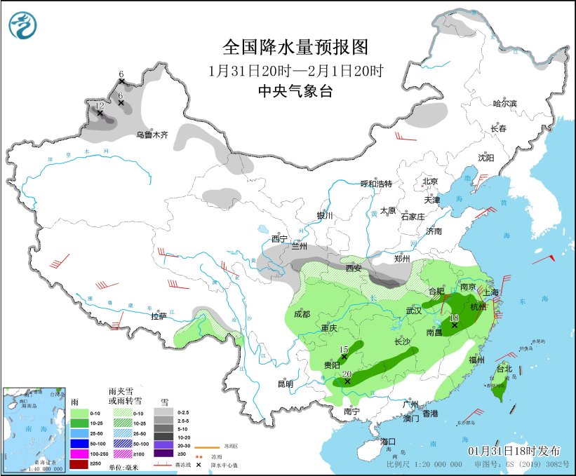
Figure 1 National precipitation forecast map (20:00 on January 31-20:00 on February 1)
20:00 on February 1 to 20:00 on February 2, there will be light to moderate snow or sleet in most parts of Gansu, southern Shaanxi, southern Henan, northwestern Hubei, etc., and heavy snow will be found in local areas of the Hexi Corridor in Gansu. Light rain will occur in some areas such as the western part of the Jianghuai River, most of the Jianghan River, the southern part of the Yangtze River, the western part of the South China, and the eastern part of the southwest region. There will be winds of 4 to 6 levels in some areas such as Hexi, Gansu, eastern Qinghai, most of Inner Mongolia, Liaodong Peninsula, northern Shanxi, Shandong Peninsula, southern Jiangsu and Anhui, and northern Zhejiang (see Figure 2).
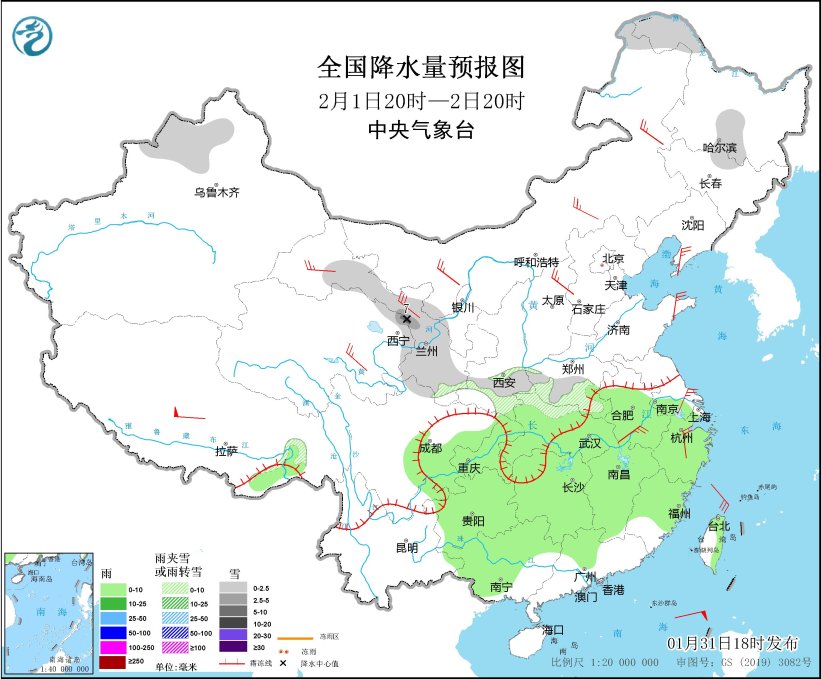
Figure 2 National precipitation forecast map (20:00 on February 1st to 20:00 on February 2nd)
From 20:00 on February 2nd to 20:00 on the 3rd, there will be light snow or sleet in the northern and eastern Heilongjiang, eastern Jilin, northern Shandong Peninsula. Light rain or showers will occur in some areas such as most parts of Jiangnan, South China, and southeastern areas. There will be winds of 4 to 6 levels in some areas such as Hexi, Gansu, eastern Qinghai, central and eastern Inner Mongolia, western Liaoning and Liaodong Peninsula, northern North China, Shandong Peninsula, northern Zhejiang (see Figure 3).
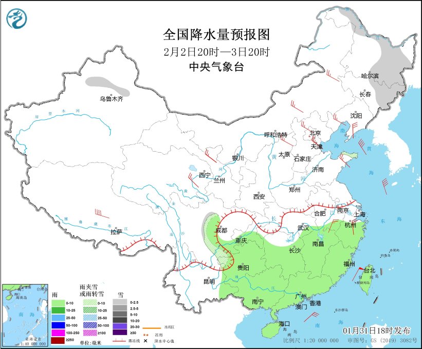
Figure 3 National precipitation forecast chart (20:00 on February 2-20:00 on March 3)