At present, the impact of the cold wave on my country's land has basically ended, and the heating in the south will be the most significant. It is expected that the maximum temperature of 10℃ will be lifted north to northern Henan tomorrow, and the maximum temperature in many places in South China and southern Jiangnan will rise above 20℃ tomorrow and the day after tomorrow, and many places in the middle and lower reaches of the Yangtze River will also rise to around 15℃.
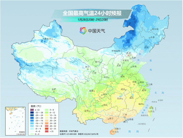
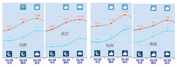
In big cities, the acquired maximum temperatures such as Hefei, Wuhan, Hangzhou and Nanchang will reach above 15℃, which is nearly 10℃ higher than the same period in previous years.
But in the second half of the holiday, cold air will affect the central and eastern regions. The temperature in Jianghuai, Jiangnan and other places fluctuate greatly, and the overall trend is rising first and then falling.
After the cold wave in the north, the temperature rises slightly weak, especially in the Northeast, where the cold is prominent after snow. Like Shenyang, the lowest temperature may continue to hit new lows this winter. In most other northern regions until the end of the Spring Festival holiday, the temperature will remain low or close to the same period of the previous year. For example, the highest temperatures in Beijing and Tianjin in the next seven days will be around 0 to 2℃.
---------------------------------------------------------------------------------------------------------------------------------------------------------------------------------------------------------------------------------------------------------
Tonight to tomorrow, most parts of the country will have few rains and snow, and the first day of the Lunar New Year will be ushered in the clear sunshine. However, rain and snow still occur in the northeast and southwest regions.
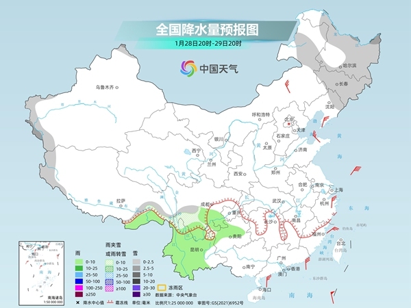
From the evening of the second day of the Lunar New Year, as the warm and humid air flow in the south is significantly strengthened to the north, rain and snow will develop rapidly again.
It is expected that from January 30 to February 2, there will be light to moderate snow or sleet in the eastern part of the Qinghai-Tibet Plateau, southeastern part of the northwest region, southern North China, Huanghuai, Northeast China, etc., among which there will be heavy snow in some areas in southeastern Gansu, southern Shaanxi, western Henan, northwestern Hubei and eastern Tibet, and local blizzards; there will be light to moderate rain in most of the south, and local heavy rain.
It should be noted that snowfall in southern Shaanxi, southern Shanxi, southern Hebei, Henan, Shandong and other places is still uncertain. There are variables in the degree of warm and humid air flow northward. The intensity of the snowfall range may be adjusted. Please continue to pay attention to the approaching forecast.