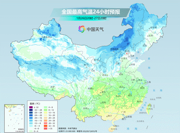
CCTV News: According to China Weather Network, the cold wave is affecting my country. The actual cooling pictures are all blue and purple. There are two "main positions" for cooling down today. The northern core area is located in central and eastern Inner Mongolia, Shanxi, northern and western Hebei, while the southern one is concentrated in Yunnan, Guangdong and Guangxi.
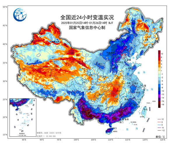
Friends in Yunnan, Guangxi and Guangdong have the most obvious feelings about today's cooling. Compared with the same time yesterday, the cooling rate in some areas exceeded 12℃, and even reached more than 16℃.
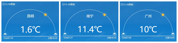
Like Kunming, the highest temperature yesterday exceeded 19℃, and the temperature began to decline all the way at night. Today, the temperature remained at around 2℃. At the same time, there was snowfall, as if back from spring to winter. The afternoon temperature in Guangzhou and Nanning is only above 10℃.
At the same time, during the day today, the rainy and snowy area continues to east, extending from eastern Inner Mongolia to some areas of Anhui, Zhejiang and Fujian.
The Spring Festival holiday is right in front of you, will it still be cold? Is there still rain and snow?
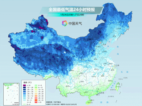
The temperature in the north is generally low, and the temperature in the south is gradually rising
The lowest temperature of this round of cold wave is mainly tomorrow and the day after tomorrow. The lowest temperature-10℃ line will be pushed to northern Shandong and southern Shaanxi, and the 0℃ line will be pushed to southern Jiangnan, southern Guizhou and northern Yunnan. The lowest temperature in many places in the north will hit a new low since this winter.
After the end of the cold air influence, the temperature in most parts of the north will be weak in recovery in the next seven days. The temperatures in places like Beijing, Tianjin, Hebei, Shanxi, Shaanxi, most of Inner Mongolia, and central and southern Xinjiang are relatively low compared with the same period of the year, so everyone needs to take measures to prevent cold and keep warm.
In the south, as the rain quickly subsides and the sunlight during the day returns, the highest temperature will start to rebound tomorrow, gradually returning to normal or relatively high levels throughout the year. From New Year's Eve to the third day of the Chinese New Year, the maximum temperature in the middle and lower reaches of the Yangtze River can rise to around 15°C, locally exceeding 20°C.
When starting from the fourth day of the Lunar New Year, cold air will affect the central and eastern regions, and the temperature will drop by 4 to 6℃, and the temperature in various places will fluctuate and decline. Since the forecast time is long, everyone should also pay attention to the approaching forecast.
Most of the country is sparsely rained and snowed to welcome the Spring Festival
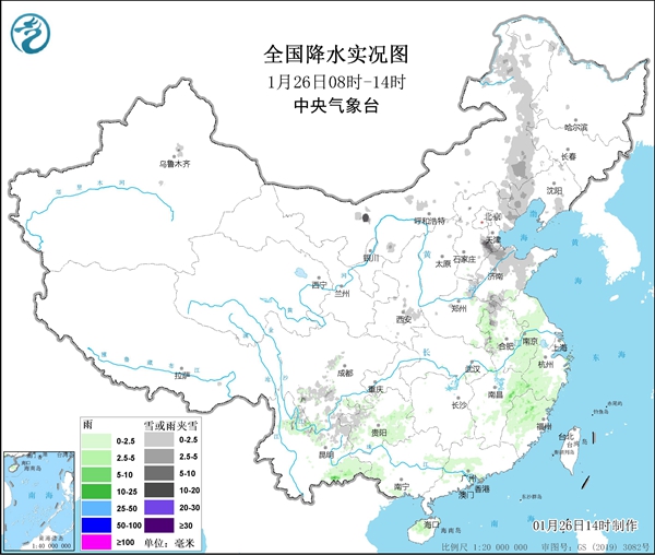
In the next three days, large-scale rain and snow will come to an end, and most areas will usher in the Spring Festival in a clear sun. However, precipitation continued in the Northeast and Southwest regions, with heavy to blizzards in some areas of Liaoning and Jilin, and local heavy blizzards.
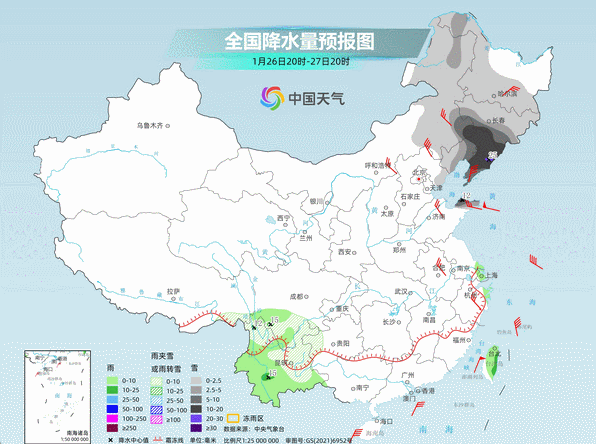
But starting from the second day of the Lunar New Year, the number of rain and snow in my country has increased again, and there will be another large-scale rain and snow weather process.
It is expected that there will be light to moderate snow or sleet in the eastern Qinghai-Tibet Plateau, southern Gansu, southern Shaanxi, southern North China, Huanghuai and Northeast China, heavy snow, and light to moderate rain in most areas in the south.
The Spring Festival is coming soon. Remember to pay attention to the latest weather conditions when you travel. If there is rain and snow, pay attention to traffic safety. I hope everyone can have a safe and happy New Year.