CCTV News: According to China Weather Network, today and tomorrow (January 21 to 22), most of the country will have few rains and snow, and the temperature will be relatively high. The temperature in many places in the south will rise to the recent highs. The maximum temperature in large areas of Jiangnan and South China can reach above 20℃, and many places will experience the warmth ahead of time. The day after tomorrow, a strong cold air will cool down with rain, snow, strong winds and strong winds. The peak period of the Spring Festival travel rush is approaching, and the public should pay attention to travel safety.
The south of the Yangtze River and South China will experience the warmth of advancement. Cold air will cause a sharp cooling starting from the 23rd.
The cold air force has been weak recently. Yesterday, most areas of the country entered the Great Cold solar term in high school compared with the same period in the same period. In the next three days, most parts of the country will continue to maintain a warmer weather pattern. Many places in the south will reach the recent highest point today and tomorrow. The maximum temperature in large areas of Jiangnan and South China can reach above 20℃. Many places warm during the day to the level that is only available during the Spring Equinox or even during the Qingming Festival. In cities, Changsha will remain above 20℃ in the next three days, and the warmth level is rare in the local area at the same time.
It should be noted that due to the slow recovery of the minimum temperature, the temperature difference between day and night in most parts of the country is still large, generally exceeding 10℃ or even 15℃. Spring is already in the daytime today in places like Nanjing and Hefei, but the minimum temperature at night is only above 0℃. The public needs to wear clothes to keep warm when traveling in the morning and evening.
With a new powerful cold air coming, this advanced warmth will be interrupted. From the 23rd to the 27th, cold air will move eastward and south to affect my country. It is expected that it will mainly affect Xinjiang on the 23rd, and will gradually affect most areas in the central and eastern regions from the 24th. The cumulative cooling rate in some areas can reach 14 to 16℃, accompanied by strong winds. The public needs to pay attention to temperature changes and add clothes to keep warm in time.
Most of the country will continue to maintain a clear and dry pattern. The rain and snow in the central and eastern regions will increase from the day after tomorrow.
Before the arrival of cold air, most of the country will continue to be clear and dry today and tomorrow, and rain and snow will be scattered in Xinjiang, Heilongjiang and Sichuan and Chongqing regions. The day after tomorrow, the cold air moves eastward and goes south to meet the warm and humid air currents, and the central and eastern regions will usher in a large-scale rain and snow weather process from west to east.
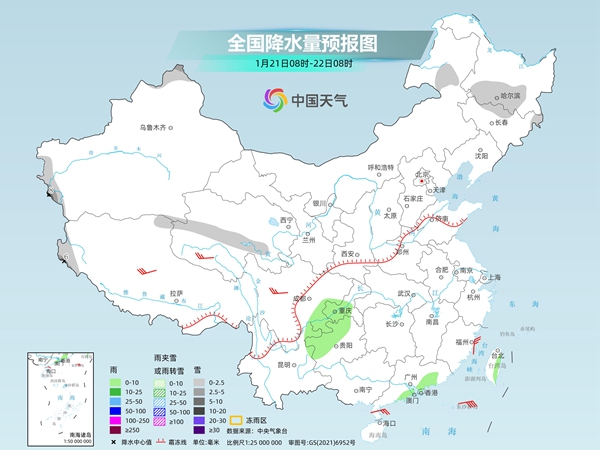
The Central Meteorological Observatory predicts that today, there will be light to moderate snow in some areas of northern Xinjiang and western southern Xinjiang, western Tibet, central Qinghai, northeastern Inner Mongolia, southern Heilongjiang, northern Jilin, and other places. Among them, there will be heavy snow in some areas of mountainous areas in western Xinjiang and western Tibet. Light rain will occur in some areas such as southeastern Sichuan Basin, central and western Chongqing, central and western Guizhou, northeastern Yunnan, southern Guangdong coastal areas, and eastern Taiwan Island.
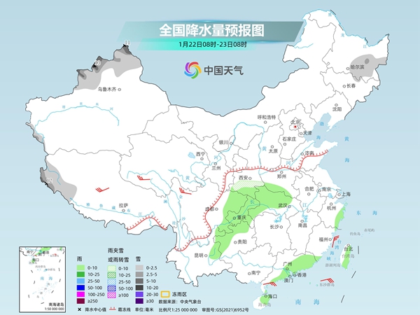
Tomorrow, there will be light to moderate snow or sleet in some areas of northern Xinjiang, southwestern Tibet, southern Shaanxi, southeastern Heilongjiang, among which there will be heavy snow or blizzards in some areas of northern Xinjiang, the Ili River Valley, and southwestern Tibet. Light rain will occur in some areas such as southern Shaanxi, southern Henan, eastern Sichuan, Chongqing, central and western Hubei, central and western Guizhou, northeastern Yunnan, southern Guangdong coastal areas, northeastern Hainan Island, and eastern Taiwan Island.
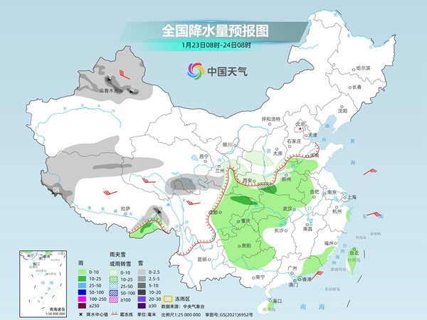
The day after tomorrow, there will be light to moderate snow or sleet in some areas of northern Xinjiang and southern Xinjiang basin, northern and southeastern Tibet, southern and western Qinghai, southern Gansu, and other areas. Among them, there will be heavy snow or blizzards in some areas of northern Xinjiang along the Tianshan area and western Tibet. Light to moderate rain will occur in some areas such as southeastern Tibet, eastern Southwest, southeastern Northwest, Huanghuai, Jianghan, western Jianghuai, northern Hunan, northern Guangxi, southeastern Guangdong, southern Fujian, Taiwan Island.
China Weather Network reminds that the peak period of the 2025 Spring Festival travel rush is coming soon, and the country's rain and snow are gradually increasing the day after tomorrow. The northwest, northeast, central and southern North China, the Huanghuai, the western part of Jianghan may experience heavy snowfall. At present, the forecast time is relatively long. It is recommended that the public pay attention to the approaching forecast and warning information, plan the route to return home in the Spring Festival travel rush in advance, and pay attention to preventing the adverse effects of rain, snow and freezing weather on travel.