Original title: Cold air is about to make efforts to break the warmer pattern! Is the first snow in the south "arrival"? !
China Weather Network News Today (January 5), we ushered in the Little Cold solar term among the twenty-four solar terms, representing the coldest period of the year. However, this year's Xiaohan started a bit warm. Starting tomorrow, a new cold air will gradually affect central and eastern my country, breaking the pattern of warmer temperatures. What else should I pay attention to next week’s weather?
Cold air is ready to go. The weather has a major turning point in the cold and cold weather
Recently, the temperature in most parts of the country is slightly higher than the same period of the previous year. Today, in Xiaohan, the warmer level in many places has even reached the recent high. However, a new cold air is ready to go, and its arrival will change the weather and warm pattern.
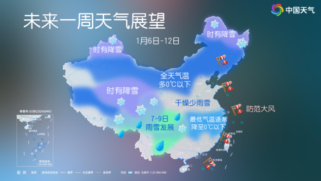
The Central Meteorological Observatory predicts that from the night of the 6th to the 9th, the southwest and most parts of the central and eastern regions will have a local cooling of 4 to 6℃, and the northeast, Jianghan, western Jiangnan, Guizhou and other places will have a local cooling of more than 8℃, and winds of 4 to 6 degrees will be found in central and eastern Inner Mongolia, northern North China, and southern Northeast China.

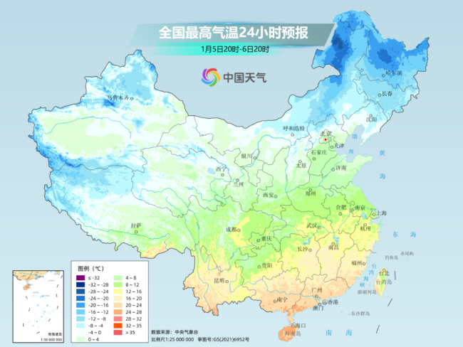
Especially in the areas from the Huanghuai to Jiangnan, the temperature fluctuations are the most obvious. Today, the highest temperature in most of the above-mentioned areas is still around 15℃, but after the cooling, it is expected that the temperature in the above-mentioned areas will fall to the bottom on the 9th, generally less than 5℃. Like Changsha, the highest temperature in tomorrow will continue to rise to 18℃, which is nearly 10℃ higher than the same period in the previous year; on the 9th, the highest temperature in Changsha will fall to 7℃, with a cumulative decline of 11℃.