CCTV News: According to China Weather Network, today (January 5), most of the country will enter the Little Cold solar term in a higher temperature than the same period last year. From tomorrow, the arrival of a new cold air will break this warm situation, and most of the central and eastern regions will gradually usher in a significant cooling. In terms of precipitation, most of the country will have clear and dry weather today and tomorrow. The precipitation in the southwest region will develop the day after tomorrow, and will gradually expand eastward to the south of the Yangtze River. Some areas may undergo rain and snow conversion.
The temperature in most parts of the country will reach the recent highs, and cold air will create strong winds and cool down the central and eastern regions from tomorrow.
Since the "Nine-year-old" winter solstice, most parts of the country have maintained a relatively warm weather pattern. Today, the Little Cold Solar Period has entered the Little Cold Solar. The warmer level in many places has reached the recent high. The maximum temperature of the 10℃ line will be lifted north to southern North China. The maximum temperature in most parts of Jiangnan can exceed 15℃, and South China can generally reach above 20℃. Among them, the maximum temperature in major cities such as Hefei, Wuhan, Nanjing, and Changsha is about 6℃ higher than the same period in the previous year.
However, the arrival of a new cold air will break this warm situation from tomorrow. The Central Meteorological Observatory predicts that due to the influence of cold air, from the night of the 6th to the 9th, the southwest and most parts of the central and eastern regions will have a local cooling of 4 to 6℃, and the northeast, Jianghan, western Jiangnan, Guizhou and other places will have a local cooling of more than 8℃.
In big cities, the highest temperature in Hefei today will reach 15℃, and the temperature will gradually drop from tomorrow. The highest temperature on the 9th will fall to 1℃, which is expected to break the new temperature low since this winter. In addition, Nanjing and Changsha may also spend the coldest day since this winter on the 9th. The temperature has dropped significantly, and the public needs to add clothes in time to keep warm.
In addition to bringing cooling, this cold air will also bring strong winds to many places in the north. From the four days tomorrow, winds of level 4 to 6 will occur in northern North China and Northeast China. The wind-cold effect in the above areas is obvious. The public should pay attention to preventing wind and cold when going out, especially keeping warm on the head and neck, and beingware of the occurrence of respiratory system, cardiovascular and cerebrovascular diseases.
Most of the country's sunny and dryness continues. The rain and snow weather in the southwest region develops and gradually expands eastward from the day after tomorrow. Yesterday, rainwater in many places in the south was rushed by, mainly in the eastern part of the southwest region, Jianghan, Jianghuai and Jiangnan; precipitation in the north was scattered. Monitoring shows that precipitation is sparse in most parts of the country, with light snow or sleet occurring in some areas such as northeastern Qinghai, central Gansu, central Inner Mongolia, and southeastern Jilin.
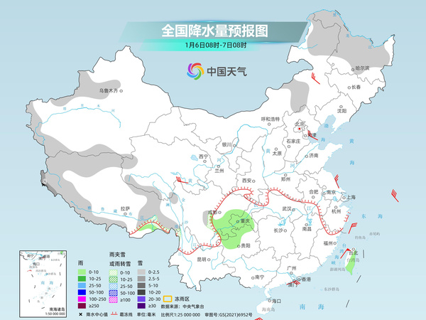
Today and tomorrow, most of the country will enter a period of sparse precipitation, and snowfall will occur in Xinjiang, Tibet, Heilongjiang and other places. The day after tomorrow, as the cold air moves southward and the southern branch trough moves eastward, rain and snow weather in the southwest develops first and gradually expands eastward to the Jiangnan area.
The Central Meteorological Observatory predicts that today, there will be light to moderate snow in some areas of the mountainous areas in western southern Xinjiang, western Tibet, northwestern and southeastern Heilongjiang, and eastern Jilin. Among them, there will be heavy snow in some areas in western southern Xinjiang.
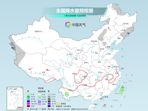
Tomorrow, there will be light to moderate snow or sleet in some areas of the Yili River Valley in Xinjiang and the high-altitude mountainous areas in southern Xinjiang, northwestern and southern Tibet, southern Qinghai, northeastern Inner Mongolia, and most of Heilongjiang. Among them, there will be heavy snow in some areas in southwestern Tibet.
The day after tomorrow, there will be light snow or sleet in some areas such as high-altitude mountainous areas in southern Xinjiang, central and eastern Qinghai Plateau, central and eastern Inner Mongolia, central and northern Inner Mongolia, central and northern Northeastern Yunnan, and northwestern Guizhou, among which moderate snow will be found in some areas such as southeast Qinghai and northern Sichuan Plateau.
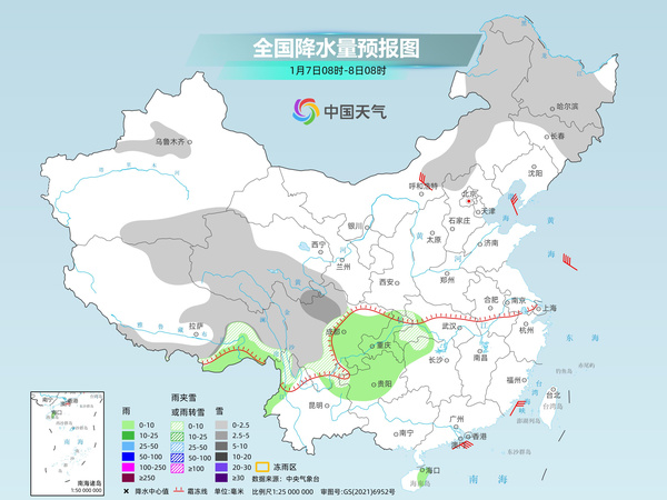
The meteorological department reminds that most of the country will be sunny and dry today and tomorrow. It is recommended that the public replenish water in time, pay attention to the safety of fire and electricity, and beware of fires. A new round of precipitation in the south will be launched the day after tomorrow. As the temperature in various places gradually drops, some areas may experience rain and snow, the roads are slippery and visibility is reduced, and the public needs to pay attention to travel safety.