The first cold wave in the Year of the Snake has already appeared. In the next two or three days, the cold wave will travel thousands of miles a day, quickly sweeping most parts of my country and reaching the South China Sea. Most of the central and eastern regions will usher in the "coldest day".
This cooling capacity has strong strength and wide impact.
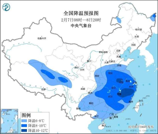
The Central Meteorological Observatory will continue to issue a blue cold wave warning at 6:00 on February 7. Affected by the cold wave, it is expected that 8:00 on the 7th to 20:00 on the 8th:
The process cooling in the southeastern part of the northwest region, southern North China, Huanghuai and other places will drop by 6 to 8°C. Among them, the cooling amplitude in some areas in southern Huanghuai reaches more than 10°C;
Most parts of the south will drop by 4 to 6°C, among which, some areas in Jianghuai, Jiangnan, South China and other places will drop by 8 to 10°C, and the local cooling amplitude in central and eastern Jiangnan can reach more than 10°C.
Specifically, the morning of the 7th to the 8th is the core period of the impact of this cooling:
On the 7th, the cooling range is the widest, and North China and Huanghuai will become the core areas for cooling, with the highest temperature drop reaching about 10℃, and there may be a rare cold feeling in the same period.
On the 8th, the cooling area will continue to expand southward. The maximum temperature in southern Hebei to Jiangsu, Anhui and other places will be only above 0℃, while the maximum temperature in many places in Jiangnan will be only around 5℃.
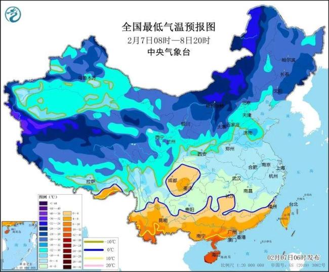
The lowest temperature is mostly in the morning of the 8th to the 9th. The lowest temperature 0℃ line will press south to the southern part of Guizhou-Nanling area. The lowest temperature north of the Yangtze River is generally less than -5℃, and the areas north of the Yellow River are mostly below -10℃.