
Às 6:00 de 26 de janeiro, o Observatório Meteorológico Central emitiu três avisos: continue a emitir avisos amarelos para ventos fortes, avisos azuis para ondas frias e avisos azuis para nevascas. Vamos aprender sobre as condições climáticas nos últimos dias.
O aviso amarelo para ventos fortes continua sendo emitido. Hoje, as rajadas de ventos em muitos lugares no centro e no leste da China podem atingir o nível 7 a 9
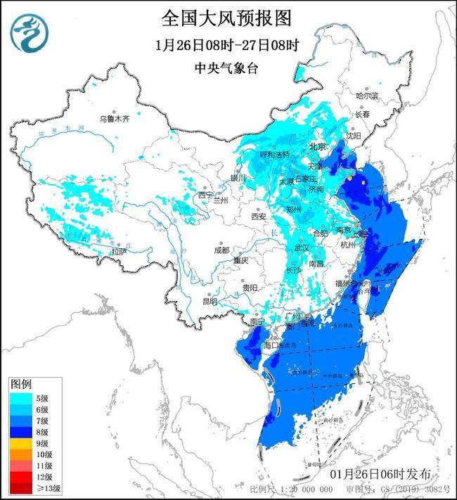
O Observatório Meteorológico Central continua a emitir um aviso amarelo para ventos fortes às 6:00 de 26 de janeiro. eastern Inner Mongolia, northern Shaanxi, Shanxi, Hebei, western and southern Liaoning, Beijing, Tianjin, Shandong, most of Henan, central and eastern Hubei, eastern Hunan, central and northern Anhui, most of Jiangsu, Shanghai, Zhejiang coastal areas, northern Jiangxi, eastern Guangxi, Guangdong As áreas costeiras terão ventos do norte de cerca de 5 níveis e rajadas de 7 a 9 níveis;
O mar de Bohai, Estreito de Bohai, a maior parte do Mar Amarelo, a maior parte do Mar da China Oriental, o Estreito de Taiwan, o oceano a leste de Taiwan, a maior parte do Mar da China Meridional, e o Golfo de Beibu terá fortes ventos de cerca de 7 a 8 níveis e rajadas de 9 a 10 níveis, entre os níveis de 10 a um vento em alguns anos.
 8:00 on January 27th to 8:00 on January 28th:
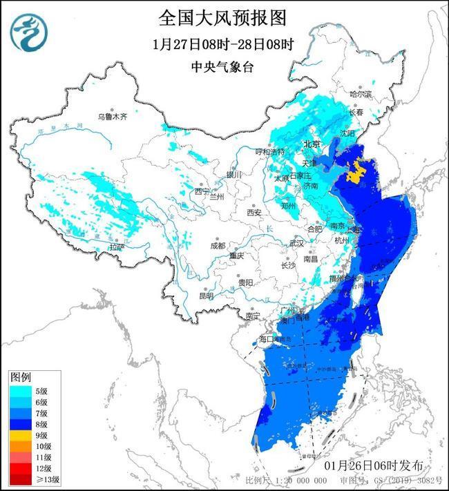
In the central and western Tibet, eastern Qinghai, central and eastern Inner Mongolia, western and southern Liaoning, eastern Shanxi, most of Hebei, Beijing, Tianjin, central Henan, most of Shandong, northeastern Anhui, most of Jiangsu, Shanghai, Zhejiang coastal areas, Fujian coastal areas, Guangdong coastal areas, etc., there will be northerly winds about level 5 and gusts of level 7 to 9;
The Bohai Sea, Bohai Strait, Yellow Sea, East China Sea, Taiwan Strait, the ocean east of Taiwan, and most of the South China Sea will have strong winds of level 7 to 8 and gusts of level 9 to 10, among which the Bohai Strait, the northern and central parts of the Yellow Sea can reach level 9 and gusts of level 10 to 11.
Defense Guide:
The Central Meteorological Observatory and the China Maritime Search and Rescue Center remind ships and personnel who are sailing and operating in the sea area affected by strong winds to return to the port to shelter, prevent ships from anchoring, stranding and collision. Relevant departments should strengthen port facilities and make full preparations for prevention;
Forest, grassland, and urban fire prevention departments are ready for fire prevention, airports, railways, highways and other traffic management departments should take measures to ensure traffic safety;
Stop high-altitude and water outdoor operations and recreational activities, stop open-air gatherings, cut off outdoor dangerous power sources, reinforce or properly place fences, trellis billboards, simple facilities and other buildings que são facilmente soprados por ventos fortes;
Peals e veículos não devem permanecer em edifícios temporários, como edifícios altos, outdoors ou sob árvores.
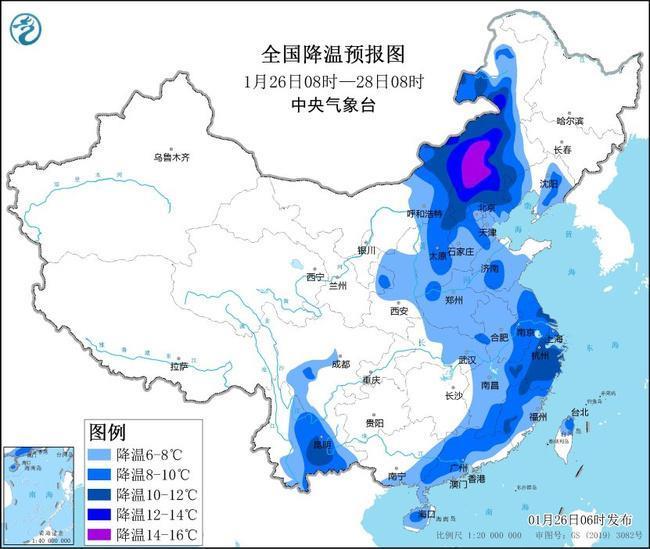
Aviso azul para ondas frias: A maioria dos ventos fortes nas regiões central e oriental esfriará mais de 12 ℃
O Observatório Meteorológico Central emitiu um aviso azul "cke" CKe "mais de 26 de janeiro
Espera-se que das 8:00 de 26 de janeiro às 20:00 em 28 de janeiro:
A temperatura no centro e no leste da Mongólia Interior, no nordeste do nordeste, a maior parte do norte da China, o sul da China, o sul da China, o sul da China, o sul da China, o sul da China, o sul da China, o sul da China, o sul da China, o sul da China, o sul da China, o sul da China, o sul da China, o sul da China, o sul da China, o sul da China, o sul da China, o sul da China. por 6 a 10 ° C. Entre eles, a amplitude de resfriamento em algumas áreas da Mongólia Interior central e oriental pode atingir mais de 12 ° C.
 -->
-->