CCTV News: According to China Weather Network, the south will maintain a rainy weather pattern in the next three days (February 18-20), and the north will also develop more precipitation tonight. Rain and snow will occur from west to east from the east of the northwest to the Huanghuai region. This week, the cold air that affects my country's activity, will decline in temperatures in most parts of the country and will gradually turn to a lower state than the same period of the previous year.
The rain in the south continues in large areas, and precipitation in the north will increase briefly
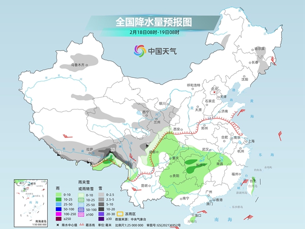
Yesterday, precipitation in my country mainly occurred in parts of the eastern part of the southwest region, western Jiangnan and Tibet. Among them, light to moderate rain occurred in southwestern Sichuan Basin, southeastern and northwestern Guizhou, central and southern Hunan, central and northern Jiangxi, central and northern Zhejiang, western Fujian, and other places; light snow or sleet occurred in central and eastern Tibet, southern Qinghai, northwestern Sichuan, and southern Gansu.
In the next three days, there will still be large-scale rainy weather in the south, and some areas of Guizhou, Hunan, Jiangxi, Zhejiang and other places will experience obvious rainfall; at the same time, the starting and precipitation in many places in the north will also increase briefly tonight, and there will be rain and snow from west to east from the eastern part of the northwest to the Huanghuai region.
The Central Meteorological Observatory predicts that today, there will be light to moderate snow or sleet in eastern Jilin, the Tianshan area along Xinjiang, eastern and southern Tibet, eastern and central Qinghai, central and southern Gansu, most of Ningxia, western Sichuan Plateau, and northwestern Yunnan, among which there will be heavy to moderate snow in some areas in eastern and southern Tibet. Light to moderate rain will occur in some areas such as southeastern Tibet, southern Jianghan, northern and western Jiangnan, eastern Southwest, northwestern South China, eastern Hainan Island, and eastern Taiwan Island.
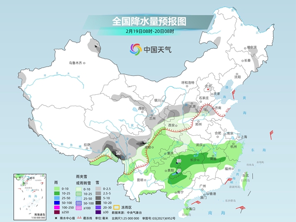
Tomorrow, there will be light to moderate snow or sleet in some areas of eastern Altay, eastern Tibet, southern Gansu Qilian Mountains, southern Ningxia, Shaanxi, southern North China, eastern Shandong, western Sichuan Plateau, western Hubei, western Sichuan Plateau, northwestern Yunnan, among which there will be heavy to moderate snow in some areas in southeastern Tibet and northern western Sichuan Plateau. There will be light to moderate rain in some areas of the eastern part of Jianghan, most of the Jiangnan region, eastern southwestern region, northern south China and western region, among which there will be heavy rain in some parts of eastern Guizhou.
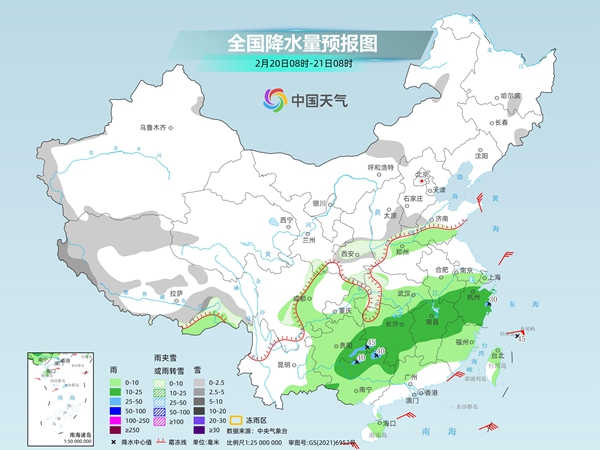
The day after tomorrow, there will be light to moderate snow or sleet in the mountainous areas of southern Xinjiang, western Tibet and southeastern Tibet, central Shaanxi, southern North China, western Hubei and other areas. There will be light to moderate rain in some areas such as southeastern Shandong, northern Henan, central and southern Anhui, most of Hubei, Jiangnan, eastern southwest region, eastern Yunnan, most of South China, and most of Taiwan Island. Among them, there will be heavy rain in some places such as southwestern Hunan, eastern Zhejiang, southeast Guizhou, and northeast Guangxi.
The meteorological department reminds that overall, precipitation is frequent in southwest, south China, Jiangnan and other places this week, especially rainfall in Guizhou and Hunan areas almost every day. The public should pay attention to preventing the adverse effects of slippery roads and reduced visibility on transportation. In addition, weak lightning and weak convective precipitation may occur in some areas in eastern Yunnan, Guizhou, Hunan and other places. It is recommended that everyone pay attention to the approaching weather and try to minimize going out when strong convective weather occurs.
The temperature in most parts of the country will decline in fluctuations, with dry and cold in the north being the main one in the south being significantly wet and cold
The cold air affecting my country this week is relatively active, and the temperature in most areas will decline in fluctuations and gradually turn to a lower state than the same period in the previous year. Among them, the cooling in the north is more obvious, and the windy weather is mainly dry and cold. Since the early temperature rises in Northeast China, North China, Huanghuai and other places is significantly higher, the cumulative cooling rate is relatively large, generally reaching above 10℃. The low temperature will occur around the 21st. The highest temperature in the central and northern parts of the Northeast region will fall to less than minus 5℃, northern parts of North China will fall to near freezing point, around 5℃ in the central and southern parts, and less than 10℃ in the Huanghuai region.
In the south, affected by the combined influence of cold air and frequent cloudy and rainy weather, in the second half of this week, the highest temperature in the eastern part of the southwest region to most parts of Jiangnan, Jianghuai and other places are mostly less than 10℃. Among them, the wet and cold feeling in many places in Guizhou and Hunan will run throughout the day.
The meteorological department reminds that most of the north are dry and windy, and the wind-cold effect is obvious. Everyone needs to take measures to prevent cold and keep warm when going out, especially to keep warm on the head and neck. You can eat more pears, tremella, yam and other foods to relieve dryness; the south is obviously wet and cold, so you should pay attention to the safety of using fire and electricity when heating indoors.