CCTV News: According to the Central Meteorological Observatory, during the day today, precipitation in most parts of the country was weak, and cooling occurred in Zhejiang, Fujian, Jiangxi, Guangdong, Guangxi and other places. In the next three days, there will be rain and snow in eastern Tibet, northern western Sichuan Plateau and other places, and light to moderate rain in the southern areas, pay attention to the impact on Spring Festival transportation, etc.
1. Weather real
Precipitation is weak in most areas of the country, and cooling occurs in Zhejiang, Fujian, Jiangxi, Guangdong and Guangxi. During the day today, light to moderate snow or sleet occurs in southern Qinghai, southern Tibet, northwestern Yunnan. Light rain occurs in eastern Sichuan, northern Chongqing, northwestern Hunan, eastern Fujian, northeast Hainan Island, Taiwan Island, and other places, and moderate to heavy rain in central Taiwan Island.
At 14:00 today, 4 to 8°C cooling occurred in southern Zhejiang, western and northern Fujian, southern Jiangxi, central and northern Guangdong, central Guangxi, and other places, with a local drop of more than 10°C.
2. Key weather forecast
There is a precipitation process from the eastern part of the southwest region to the middle and lower reaches of the Yangtze River
It is expected that from the 14th to the 15th, there will be a significant precipitation process in the eastern part of the southwest region, Jiangnan, Jianghuai, and South China. Among them, there will be heavy rain in northern Hunan, northern Jiangxi, and southern Anhui. In addition, there will be light to moderate snow or sleet in eastern Tibet, western Sichuan Plateau, northern Northeast China, and eastern Inner Mongolia.
In addition, affected by weak cold air, from the night of the 13th to the 15th, there will be northerly winds of 4 to 5 in some areas of Inner Mongolia, North China, Huanghuai, and southern Northeast China, and the temperature in some areas of central Inner Mongolia and Northeast China dropped by 4 to 6℃. There are winds of 6 to 7 levels in the East China Sea, Taiwan Strait, Bashi Strait, and northern South China Sea.
3. Specific forecast for the next three days
From 20:00 on February 13 to 20:00 on February 14, there will be light to moderate snow or sleet in some areas such as northeastern Inner Mongolia, northern Xinjiang and western mountainous areas of southern Xinjiang, northern and eastern Tibet, southern Qinghai, southeastern Gansu, northern western Sichuan Plateau, and northwestern Yunnan. Among them, there will be moderate to heavy snow (5-8 mm) in some areas in southeastern Tibet. Light to moderate rain will occur in some areas such as the western part of the Jianghuai River, most of the Jianghan River, northern and western Jiangnan, eastern and southern southwest, northwestern Guangxi, Hainan Island, and Taiwan Island. There will be winds of 4 to 6 in some areas such as northwestern Inner Mongolia and northern Tibet; there will be winds of 5 to 6 in the Taiwan Strait, Bashi Strait, and northeastern South China Sea (see Figure 1).
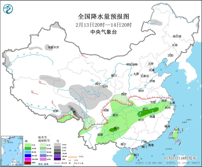
Figure 1 National precipitation forecast map (20:00 on February 13th to 20:00 on February 15th)
To be 20:00 on February 14th to 20:00 on February 15th, there will be light snow or sleet in some areas of eastern Inner Mongolia, western Heilongjiang, eastern Tibet, central western Sichuan Plateau, etc., among which moderate to heavy snow (5-9 mm) will be found in some areas of northeast Inner Mongolia and eastern Tibet. There will be light to moderate rain in some areas such as most of the Jianghuai River, eastern Jianghan, eastern Jiangnan, eastern Southwest, and most of South China, among which there will be heavy rain in some areas such as central and western Hunan. There will be winds of 4 to 6 in some areas in southeastern and western Inner Mongolia, northwestern Heilongjiang, central Zhejiang, and most of Tibet, among which there will be winds of 7 to 8 in some areas in northern Tibet; there will be winds of 5 to 6 in the East China Sea, Taiwan Strait, Bashi Strait, and northeastern South China Sea (see Figure 2).
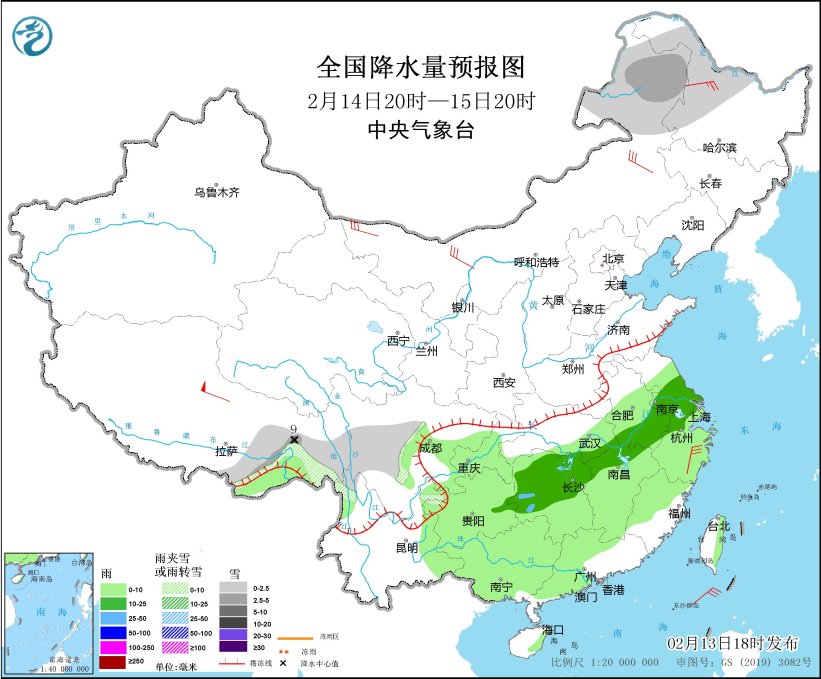
Figure 2 National precipitation forecast map (20:00 on February 14-20:00 on February 15)
To 20:00 on February 16, there will be light snow or sleet in some areas of eastern Inner Mongolia, most of Heilongjiang, central and northern Jilin, eastern Tibet, southern Qinghai, western Sichuan Plateau, and other areas, among which moderate snow will be found in some areas of southeastern Tibet. Light rain will occur in some areas such as southeastern Tibet, most of Zhejiang, southwestern Sichuan, western Guizhou, eastern Yunnan, eastern and western Guangxi, southern and central Guangdong. There will be winds of 4 to 6 in some areas such as central Inner Mongolia, southwestern Heilongjiang, Tibet, northern Hebei, and central Zhejiang. There will be winds of 5 to 6 in the Yellow Sea, East China Sea, Taiwan Strait, and Bashi Strait, with gusts of 7 (see Figure 3).
![]()
Figure 3 National precipitation forecast chart (20:00 on February 15th to 20:00 on February 16th)